
3D Scanning for Construction in Toronto & the GTA
3D Scanning for Construction in Toronto & the GTA
Why Construction Teams in Toronto Are Turning to 3D Scanning
Construction projects in Toronto and the GTA are complex — tight urban sites, aggressive timelines, and multiple trades working on top of each other. When as-built conditions don't match design documents, the result is costly RFIs, change orders, and project delays.
3D laser scanning eliminates the guesswork. By capturing millimetre-accurate spatial data of your site, Lightbound 3D gives construction teams a precise digital record of existing conditions and ongoing progress — helping you plan better, coordinate faster, and avoid expensive surprises.
Whether you're building new, renovating an existing structure, or managing a multi-phase development, our 3D scanning and BIM services provide the data your team needs to keep projects on track and on budget.
3D Scanning Supports Every Stage of Construction
For Toronto-based new construction and major renovations, accurate as-built data is also essential for Toronto Green Standard (TGS) compliance — a mandatory requirement for all Site Plan Approval submissions in the City of Toronto.
Pre-Construction and Site Documentation
Before breaking ground or starting demolition, you need to know exactly what you're working with. Our 3D scans capture complete existing conditions — structural elements, mechanical systems, underground utilities, and surrounding context — so your design team can plan with confidence. This is especially critical for renovation and adaptive reuse projects in Toronto's older building stock, where original drawings are often missing or inaccurate.
Design Coordination and Clash Detection
Point cloud data from our scans integrates directly with Revit, AutoCAD, and other AEC software, allowing your team to overlay new designs onto actual site conditions. Identify clashes between structural, mechanical, and electrical systems before they become problems in the field — saving time, reducing RFIs, and minimizing costly rework.
Construction Progress Monitoring
Track your build against design intent with scheduled scan-to-BIM comparisons. Our progress scans give project managers and stakeholders a clear, data-driven picture of what's been completed, what's behind schedule, and where deviations have occurred — all without relying on subjective field reports.
As-Built Verification and Handover
At project completion, our final scans create a precise as-built digital record of the finished structure. This documentation is invaluable for facility managers, building owners, and future renovation teams who need to understand exactly what was built and where systems are located.
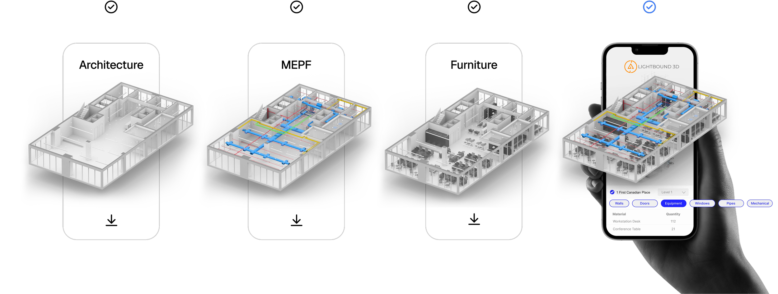
What You Get with Our Construction Scanning Services


3D Point Cloud Data — High-density laser scans delivered in formats compatible with Revit, AutoCAD, Navisworks, and other construction software.
Scan-to-BIM Models — Accurate building information models created from scan data, ready for design coordination and clash detection. Learn more about our BIM services.
As-Built Floor Plans and Sections — Scalable 2D drawings extracted from 3D data for permitting, design, and documentation.
Progress Reports — Visual comparisons of scanned conditions against design models to track construction milestones.
Matterport Virtual Tours — Optional immersive walkthroughs of your site for remote stakeholder review. See our virtual tour services.
Drone and Aerial Scanning — For large sites, rooftops, and exterior facades where ground-based scanning alone isn't sufficient.
Who We Work With
General Contractors — Get accurate existing conditions before a project starts, track progress throughout, and deliver verified as-built documentation at handover. Our scans reduce the time your team spends re-measuring and verifying field conditions.
Architects and Designers — Start your design process with reliable as-built data instead of outdated drawings. Our point clouds and BIM models integrate directly with your preferred design software, giving you a precise foundation for renovation, addition, and adaptive reuse projects.
Construction Managers and Owners' Representatives — Monitor progress remotely, compare built conditions against design intent, and maintain a clear digital record of every phase. Our scans give you the visibility you need without increasing your time on site.
Mechanical, Electrical, and Plumbing (MEP) Contractors — Identify routing conflicts before installation begins. Our scans capture existing mechanical rooms, ceiling plenums, and riser shafts with the detail needed for precise MEP coordination.
Developers and Property Owners — Document your building's current state before renovation, track the construction process, and receive a comprehensive digital asset at project close. This data supports future maintenance, tenant fit-outs, and building management.
Our Construction Scanning Process
Discovery Call — We discuss your project scope, timeline, and deliverables to recommend the right scanning approach for your needs.
On-Site Scanning — Our team arrives with professional-grade LiDAR scanners and captures your site efficiently, with minimal disruption to ongoing work. Most commercial spaces are scanned at approximately 1,000 square feet per hour.
Data Processing — We register and process your scan data into clean, accurate point clouds. If BIM models or floor plans are required, our modeling team builds them to your specifications.
Cloud Delivery — All deliverables are shared via our secure cloud platform, giving your team access to view, measure, and collaborate from anywhere.
Typical turnaround: 3–7 business days depending on project size and deliverable complexity.
3D Scanning for Construction — Frequently Asked Questions
-
Traditional surveying captures individual measurement points, while 3D laser scanning captures millions of data points in minutes, creating a complete spatial record of the entire site. This means your team can take measurements from the scan data long after leaving the site — no return visits needed for missed dimensions.
-
Yes. We deliver point cloud data in industry-standard formats (RCP, E57, LAS) that import directly into Revit, AutoCAD, Navisworks, BIM 360, and other AEC software. We also offer full scan-to-BIM modeling if your team needs ready-to-use Revit models.
-
It depends on the project. For fast-track builds, monthly scans are common. For longer-duration projects, quarterly scans at key milestones — such as after structural completion, rough-in, and fit-out — are usually sufficient. We can recommend a schedule based on your project timeline.
-
Yes. We routinely scan active job sites and occupied buildings. Our scanning process is non-invasive and doesn't require work stoppages. We coordinate with your site team to schedule scans during appropriate windows.
-
We scan everything from single-floor tenant fit-outs to multi-tower developments. Our team and equipment scale to match the project, and we've worked across commercial, institutional, residential, and industrial sectors throughout Toronto and the GTA.
-
Lightbound 3D serves construction projects across Toronto, Mississauga, Brampton, Vaughan, Markham, Oakville, Hamilton, and the Golden Horseshoe in Southern Ontario. For larger or multi-site projects outside this region, service can be arranged by request.
-
You can — Matterport cameras are available for rent or purchase. However, professional results require more than the hardware. Scan registration, lighting management, stitching errors, and tour hosting all affect the final quality. Lightbound 3D's Matterport tours include professional setup, quality-controlled output, proper floor plan integration, and ongoing hosted access. For a listing or commercial space you're presenting to clients, the difference in quality is visible.
-
Our Matterport virtual tour package ($249) includes the full 3D scan, professionally registered and processed, hosted on the Matterport platform. Adding a floor plan brings the package to $349. Space hosting is $9.99/month after the initial period. All tours are delivered ready to embed on your listing, website, or share with clients.
-
Yes — embedded virtual tours increase time-on-page significantly, which is a positive engagement signal for search engines. More directly, properties with virtual tours generate more inquiries and shares, which drives organic traffic to listing pages. For commercial properties, a hosted Matterport tour gives Google something to index that static photos don't.
Service Areas
Toronto, Mississauga, Brampton, Vaughan, Markham, Oakville, Hamilton, and the Golden Horseshoe in Southern Ontario.
Ready to Scan Your Construction Site?
Get accurate site data, reduce rework, and keep your project on track. Contact Lightbound 3D for a free consultation or quote.
How can we help you?
To get a quote, please tell us a bit about yourself. We will get back to you with more information for your project.